It's Thursday July 23, 2026
March 29, 2024
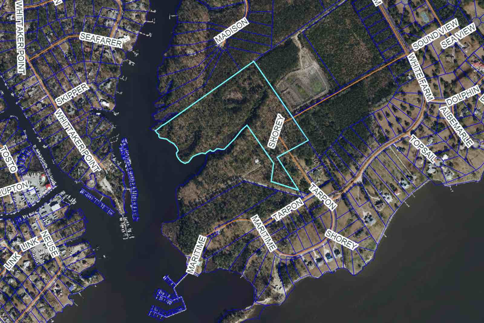
Word around town is that an RV Park has been proposed in the Dolphin Point neighborhood. Not exactly. There is a proposal for one off White Farm Rd near Whittaker Creek.Here’s the backstory: In April 2019, a request was made to the Town of Oriental to annex in about 30 acres of land. It’s a parcel bordered by Whittaker Creek to the west, the Sea Harbour dredging spoil site to the east, an undeveloped housing community to the north, and Dolphin Point to the south.
Property owner Martin Spratt intended to build multi-family homes – duplexes – at 604 Shorey Drive, and asked the parcel to be annexed into the town. Commissioners approved, and it was zoned R3 at Spratt’s request.
The parcel now up for rezoning – 604 Shorey Drive – is outlined in bright blue.R3 is a residential zoning classification, and allowing for the highest residential housing density with the least amount of restriction.
A few years passed and construction on the homes never started.
In early 2024, a new request for the Shorey Drive property came through – to divide the parcel into two lots, around 10 and 20 acres respectively. The division was approved.
The next request from Spratt was to rezone the larger lot (about 20ish acres) into an MU parcel.
A Zoning Request versus a Permit RequestMU is a Mixed Used zoning classification, meaning there can be a mix of residential and commercial uses on the property.Zoning requests require the applicant explain the proposed use of the land. However, the law states that use cannot be considered when granting or denying a zoning request. A proposed use can be changed and in the future, different owners could have a different purpose for the land.
After a zoning request is granted, a Special Use Permit or Land Use Permit must be approved before building begins.
So an application can ask for a rezoning of a parcel, with the intent to build X. But after the property is rezoned, the build can be changed from X to something else entirely – like Z. In either case, X or Z will still need to go through the permitting process – and be approved – before any building can begin.
Getting approval for one does not mean getting approval for the other.
The proposed use of the rezoned parcel: An Executive RV Park. Though Commissioners cannot consider the future use of the land in the rezoning decision, residents are definitely considering it.The Shorey Drive parcelThe rezoning has not happened yet – there is a public hearing at the monthly Town Board meeting, April 2 at 6p. At that meeting, Commissioners will hear the public, discuss the issue, and make a decision.The request in front of them is to rezone fro residential to mixed use commercial. The proposed use is for an Executive RV Park.
February Planning Board Meeting
Oriental’s Planning Board took up the request at their February meeting and spoke with the representative and engineer for the property, Susan Sayger.Sayger was the only person to present information for or against at that meeting. Members asked about access to the parcel, intent of the property owner, reasons for changing the designation, working within CAMA (Coastal Area Management Act) guidelines and the town’s own GMO (Growth Management Ordinance – a document outlining the town’s building and growth regulations).
Based on her information, the discussion, and the local and state ordinances and regulations in place, the Planning Board recommended the Commissioners set a public hearing. Planning Board members would have a second chance – at their March meeting – to hear more about the request.
Ready to Say Yes
At the February meeting, Planning Board members were ready to make a motion to approve the rezoning request based on the following:
• The GMO does not allow light, medium, or heavy industrial uses in designated flood zones. This includes warehousing, boatyards, farming, and the like along the waterfront.
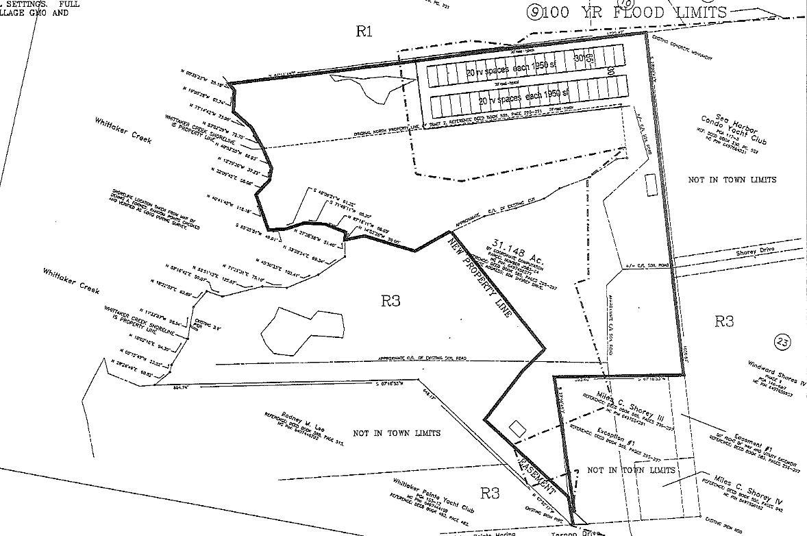
• Of the 20ish acres, only around 5 acres will be developed. The 100 year flood plain precludes much of the land from being used.
• Access to the lot. Sayger said there were three possible entrances to the lot, one directly off White Farm road and running along the Sea Harbour spoil site. It would require collaboration with Sea Harbour, but that road (if used) would bypass the Dolphin Point neighborhood and need to be brought up to code, resulting in better town infrastructure and less annoyance to residential areas. Sayger was made aware that residents would likely oppose the construction if the residential roads were used to access the lot.
• The lot is secluded from developed residential areas. The GMO also requires MU lots to be visibly shielded – by plant material or a fence.
• CAMA restrictions for building along the water are more stringent than the Town’s, and permits are required for that use. This is part of the reason only 5 or so acres of the lot is proposed for development.
• The Town’s Comprehensive Plan – one of two guiding documents – says Oriental would like a mix of residential and commercial uses.Land Use: Executive RV ParkAlso discussed, but not as part of the rezoning request, was the proposed Executive RV Park.Sayger said part of the zoning change was the cost to build: the RV Park was significantly less expensive to develop than the originally proposed duplexes. The RV Park also created a space for the larger, more expensive RVs to come visit – hence the name Executive. It would be a draw for higher end clientele. Some of those vehicles, she said, cost more than a single family home.
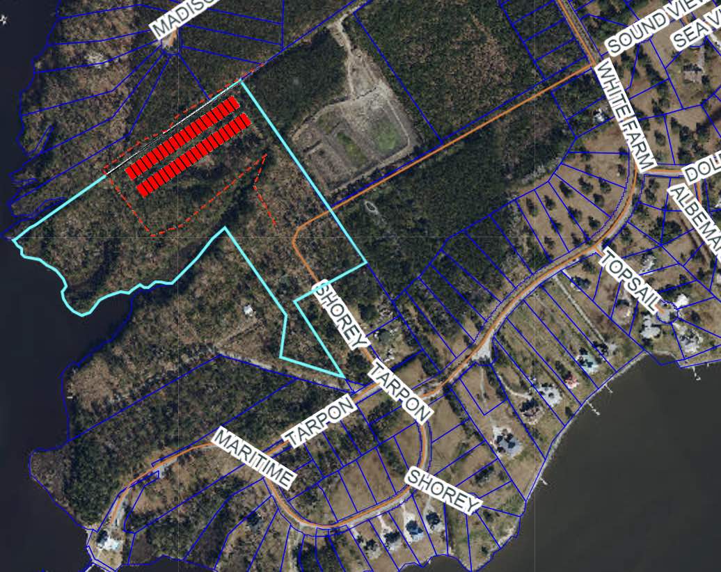
The plan is for two rows of 20 sites, 40 in total.
Planning Board members were pleased about a number of things with the proposed use:
• It would bring more tourism dollars to town.
• Created more spaces for traveling families, and though Oriental has spaces for those traveling by boat and car, it does not have much space for RVs.
• Building would mean that area would be one of the first under consideration as the the water lines are being looped and upgraded. One issue with the water lines at Dolphin Point is they terminate instead of loop. Meaning treated, drinkable water has to be flushed out of the lines when there’s less use – a waste of water and money. A looped system keeps water flowing and from becoming stagnant.
• Because it is commercial and not residential, RVs have to leave the area case of a named storm.
• In the event of a flood, it would likely be easier to clean up an empty RV sites than immovable homes. It would also mean less debris is pulled into Whittaker Creek as waters recede.604 Shorey Drive. The parcel under consideration for rezoning is outlined in bright blue. The proposed RV Park is outlined in red. The 100 year flood line is dotted red.RV Parks in Oriental are GovernedSayger was directly questioned about the RV Park deteriorating into or being left to devolve into dilapidation. Oriental has strict requirements for RV Parks in town limits (section 135 in the GMO) that directly address the appearance and maintenance in an RV Park.[It should be noted that the RV Park on Broad Street is not inside Oriental’s town limits.]
Some of the Town’s requirements:
- The park must have an opaque 8 foot fence, maintained and in good repair and appearance. Natural buffers (plants) are encouraged.
- Max density is ten RV sites per acre. Expansion requires a new permit.
- Each site must be 1,950 sq feet, a pull-through site, and a road built to DOT highway standards is required at the front and back of each space. Each site must also have room for additional vehicle parking and a space for a ‘patio area’.
- Landscaping is required, as is lighting for the sites and facilities.
- Each park must include: onsite office manager, facilities for bathrooms, showers, and laundry.
- All exposed surfaces must be covered by pavement, rock, vegetation, etc to help prevent erosion and eliminate dust.
- Wheels must remain on vehicles at all times. Road must remain in good repair.
- All sites are required to be graded to drain storm water, and a drainage survey (completed by an engineer) must be done and provided to the Town.
- No site is allowed to have an accessory structure (like a small shed).
- RV storage beyond 14 days is prohibited.
- Permanent occupancy is prohibited.
- Living in RVs is prohibited within town limits. RVs can be a temporary, continual residence up to 6 months.
- Parks must maintain logs of every guest, including date of arrival and departure.
- All vehicles must be removed within 6 hours of an issuance of a hurricane or tropical storm warning.
- There are fines for infractions of the rules and the Special Use Permit (that allows the park to operate) can be revoked in the face of violations.
Residents Air their ConcernsCommissioners set the hearing for their April 2 meeting, and notices were sent out. Residents, many from Dolphin Point, were at the Planning Board’s March meeting and voiced their concerns.Chiefly among them was the increase in traffic, the deterioration of roads (already a problem in town), and the potential for noise and disruption – both from visitors and from construction.
Residents said they had moved to the area to avoid places like this and did not want the density or the influx of an unknown element; it had the potential to lead to crime.
Planning Board members were also cautioned to remember that residents want to maintain their waterfront and not develop it.
Accessing the Spoil SiteThere’s also concerns about accessing the spoil site behind the proposed park.North of the lot is the Sea Harbour spoil site. It is owned by Sea Harbor and receives the spoil (wet mud and dirt) that results from the dredging of Pierce Creek.
The Friends of Whittaker Creek also use this site when their creek is dredged. Currently, spoils are piped in from Pierce Creek (east of spoil site) via and underground pipe. Spoils from Whittaker Creek (west of the spoil site) are piped in with a hose – going over land on the subdivided parcels.
Sea Harbour’s easement is in place until 2049. Whittaker Creek also has an easement in place, but is concerned that developing the land will interfere with their ability to access the spoil site. Especially if buildings are in the way.
What’s Next?Planing Board members do not say yes or no to the issues that come before them, but determine if those requests meet the standards (or not) of the town’s foundational documents (the Comprehensive Plan and the CAMA Land Use Plan), the regulations in the GMO, and the will of the residents.The rezoning request for 604 Shorey Drive is legally a ‘political’ decision, not an evidentiary one. This means it is up to Commissioners to decide if this is good addition for the town and its residents.
On one hand, the rezoning request meets the town’s standards. On the other, many residents are against it.
Commissioners will make the final decision at their next meeting, Tuesday, April 2, 6p at Town Hall.
Related Information• 604 Shorey Drive Rezoning Request & Resident Responses – March 2024
• Original 604 Shorey Drive Annexation Request – April 2019
• Orignal 604 Shorey Drive Rezoning Request – April 2019
• RV Park Guidelines, GMO Section 135(Allison DeWeese, writer of this article, is also the Chair of the Planning Board.)