
It's Sunday July 19, 2026
May 17, 2012
Here is a map showing the proposed land swap near the harbor between the Town of Oriental and Chris Fulcher. It is based on the schematic of the survey done by Dennis Fornes and which is part of the proposed contract.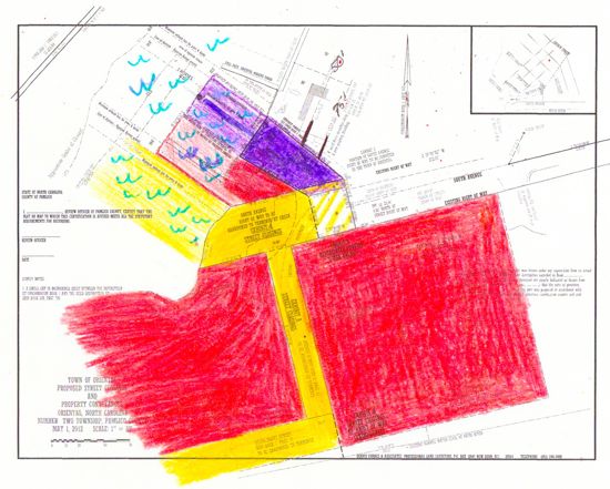 The Swap: The Town would be left with the purple area. Chris Fulcher would gain the yellow areas — rights of way — which would when combined with his current holdings – in red — would give him a sweep of land from Wall Street, right around the point (not shown in the survey) and to the edge of the Purple lot. Some Town officials have said the rights of way had no value. Their value to Mr. Fulcher were not appraised going in to the deal.
To ease comprehension of the land swap, color has been used to depict the swap and lands related to it. (The schematic on which this is based can be downloaded here.
Yellow depicts the Rights of Way the Town will give up. They include the terminus (end) of South Avenue and all of Avenue A. It is also used to show Neuse Front Street. (see below)
The lightly colored yellow is the water off of that land.
The survey map, paid for by Mr. Fulcher, does not indicate the boundaries of the riparian rights the Town would be giving up off of South Avenue. The colored-in area on this map is an approximation and may not show the full extent of what the town is giving up.
Purple denotes the parcel of land that Mr. Fulcher is giving the town. When a small parcel of right of way given up by the town is added to that lot (purple and yellow hatches) it creates a 5,002 square foot lot.
The lightly colored purple depicts the riparian rights (in the water) in which the Town could have a dock.
The survey, paid for by Mr. Fulcher, does not show the extent of the riparian rights the Town would be giving up off of South Avenue. The area colored in is an approximation based on past surveys of the area.
Red shows land that Mr. Fulcher already owns on the Neuse River water front. Red is also used to depict the parcel of land on the harbor that Mr. Fulcher will continue to own (between South Ave and the (purple) lot the Town would get.
The lightly colored red is the water off of that land.
Those land holdings extend to the lower left of this map, beyond the area colored in. They were not clearly delineated on the original schematic and so weren’t colored here.
The End ResultIf the deal goes through, Mr. Fulcher would control not only all of the red in the map, but the yellow parts as well. He would therefore control all of the land from the right of the map (Wall Street), along the Neuse riverfront, around the point from which the harbor breakwater extends (not shown on the original schematic and not shown here) past South Avenue and up to the edge of the lot – in purple – that he is giving the town.
With just the abandonment of South Avenue and Avenue A, the town would be giving up approximately 2-1/2 to 3 times as much land as it is getting in the deal.
The numbers 50 and 75 on the map show the setback from the water as required by CAMA and Neuse River Buffers. Those regulations restrict construction in those buffer areas, which could have an impact on the restrooms that Town officials say they can build there.
Still More Right Of Way “To Be Abandoned”For months, the Town has spoken of abandoning Avenue A and the end of South Avenue as part of the deal. When the contract was made public last week, another aspect emerged. Paragraph 2 states that the right-of-way abandonment would also include Neuse Front Street, among other old streets, which run under some of Chris Fulcher’s seafood plant property.
Dave Cox, a resident who has researched the history and deeds of that part of town, says that in the 1920’s Neuse Front Street was deeded to some private landowners, but was never technically abandoned.
Mayor Bill Sage says Neuse Front Street shows up on some maps and plats. Some have suggested that could have been a negotiating point the Town could have used to gain more land from Fulcher. Instead, the contract calls for the Town to formally abandon those rights of way.
The survey’s fine print says that Neuse Front Street is “to be abandoned to terminus.” It is therefore shown in yellow here as are other ROW’s that the Town would be abandoning. The full extent of that abandonment is not shown in the survey. As this map is based on the survey, it also does not show all of the Right of Way that the Town would abandon on Neuse Front Street and other old streets.