
It's Friday May 22, 2026

January 2020
The playbook for a varsity football team is more complicated than a junior varsity playbook. The varsity players, for any sport, are better than the junior varsity. Know thyself. If you are a junior varsity sailor, perhaps Beaufort should not be one of your first destinations. Cruising to Beaufort is a varsity event. It is a short 18 crow flying miles from Oriental “1SC” to Beaufort. However, those 18 miles are fraught with a variety of challenges.If you are new to sailing or cruising, I recommend other destinations first. Here are eight reasons why Beaufort is a challenging destination.
• The first navigational aid on the way to Beaufort is Adams Creek One (“1AC”). Adams Creek One was (key word was) a 15 foot lighted daymark. Unfortunately, “1AC” is now an impossible-to-see buoy. Boaters are ultimately responsible for this downgrade; too frequently, as judged by the Coast Guard, boaters ran into the rigid daymark. The Coast Guard decided to anchor a buoy rather than continually replacing the daymark’s pilings. A fiasco during the “Instead of Football Regatta” on January 1st has also caused the daymark at Garbacon to become a green can. These green cans can be difficult to find without some pre-planned headings or a chart plotter. (Don’t run into the navigational aids)
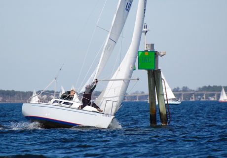
The former 1AC daymarker, during the 2012 Instead of Football Regatta.• The Intracoastal Waterway through Adams Creek is narrow. particularly just north of the Core Creek Bridge. In this area, you might pass within feet of other vessels including barges that travel between Aurora and the Port of Morehead City. These phosphate moving barges deserve some wide separation. You must be a good driver of your boat when passing in these tight quarters.
• If the mast of your boat, measured from the waterline, approaches 65 feet, you might have trouble passing under the Core Creek Bridge and Beaufort or Morehead City Bridges. Boaters with tall masts must be savvy enough to check the tides for the time they intend to pass under the bridge. As a side note; distance equals speed multiplied by time. So, if the distance from Oriental “1SC” to the Core Creek Bridge is 13 nautical miles and you are making 6 knots; the time to the Bridge will be 2.2 hours or 2 hours and 12 minutes. Departing “1SC” at 0900 puts you under the Bridge at 1112. Got it? A navigational program should give you all this.
If your chart plotter navigational program is lacking, you can check the tides at Core Creek Bridge Tides on MarineWeather.net. It is a quick and easy look. Anyway, back to the challenges of Beaufort.
• Navigation requires good situational awareness. Along the Atlantic Intracoastal Waterway (AICW), green daymarks or green buoys (cans) mark the eastern side of the channel. Red daymarks or red buoys (nuns) mark the western side. This differs from the “red right returning home” channel markers. When entering the AICW from a channel, or leaving a channel onto the AICW, most often the marks switch. Heads up. In the Port of Morehead City turning basin, the AICW turns west towards Swansboro. Colors of the marks switch. Navigation is now accomplished using channel markers, not AICW markers. To aid recognition, all AICW navigational aids will have yellow stickers. AICW greens will have square yellow stickers. AICW reds will have yellow triangles. These reflective yellow stickers help differentiate the AICW and channel markers.
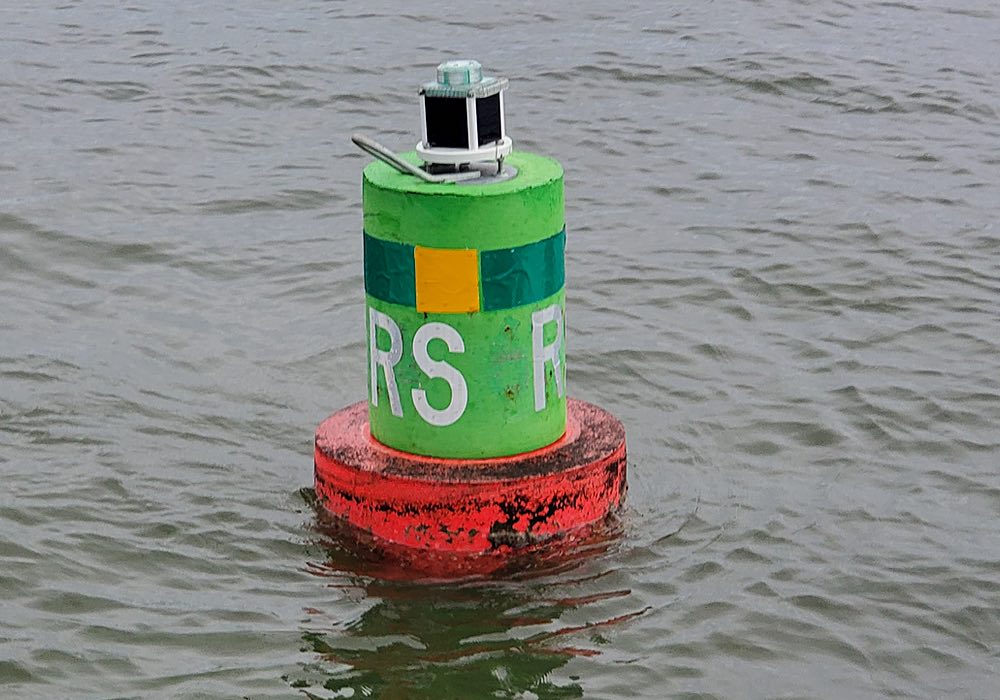
• Speaking of marks; if you don’t immediately know what this buoy means, your knowledge is deficient.
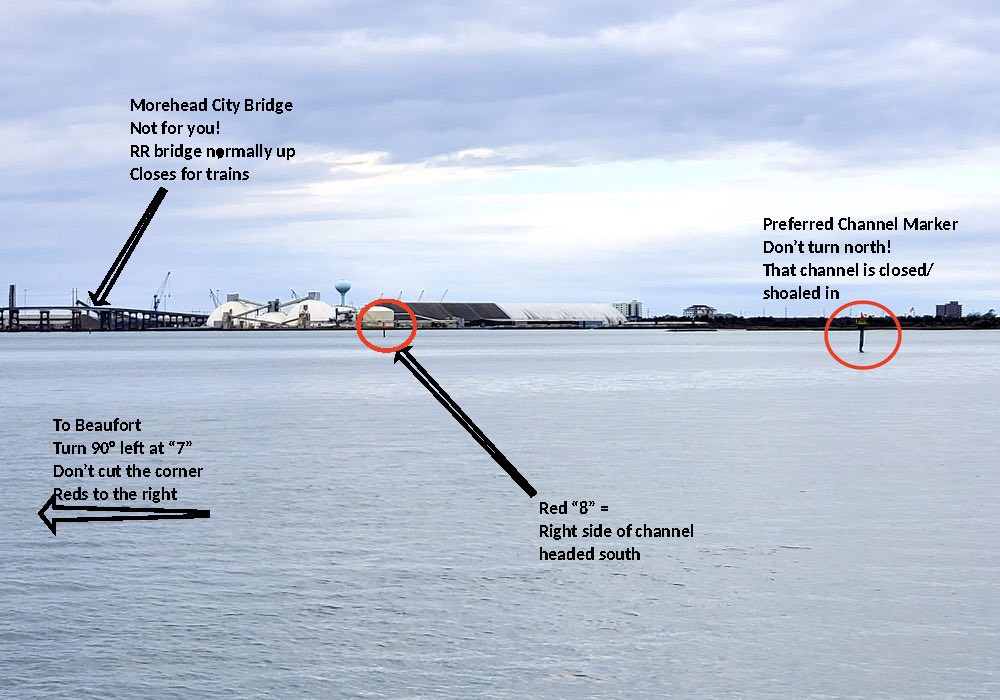
Russell Slough Junction Light.This is the Russell Slough Junction Light. This buoy (can) is a preferred channel marker and identifies the intersection of the Russell Slough and AICW. This buoy was formerly a two-color daymark with pilings. Now it is a buoy. All two color markers works like this; to utilize the preferred channel, use the top color. Or, utilizing the bottom color will guide you to the secondary channel. In this case, the top color is green with a yellow sticker. Therefore, to stay on the AICW, treat this buoy as a green. Leaving the (green/upper color) buoy to the east/port will keep you on the AICW. Leaving the (red/lower color) buoy to the west/starboard will guide you into the Russell Slough (secondary channel). This is the fork in the road where you will proceed the shorter “back way” into Beaufort or stay in the AICW and proceed the longer way through the Morehead City turning basin and around Radio Island. To make matters worse, these marks are moved/changed often. Be advised: do some study on the current/latest update chart. Be a good Captain/Navigator. Know what to expect versus figuring it out when you get there.
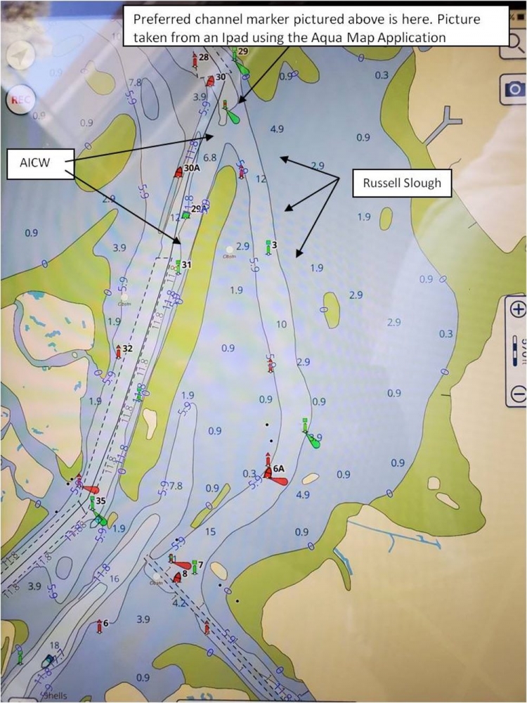
Marks in the Russell Slough are reversed.• You’ve probably already noticed from the above, the marks in the Russell Slough are reversed. Yes, reversed and wrong. If you are going to Beaufort “the back way” (not around Radio Island), heads up. Heading south, when you veer left off the AICW into the Russell Slough, the reds still mark the right side of the channel. Heading south through this stretch, greens still mark the left side.
Frankly, I don’t know why. Not on the ICW, these should be red right returning channel markers and reversed. It’s like you’re still on the AICW. Confusion. Some pre-planning chart study of this route will keep you off the bottom. Here’s a photo of an “official” NOAA chart number 11545 for the Beaufort Inlet. As you can see, the chart is busy. To sort this out, while underway and confused, is challenging. I highly recommend some pre-planning/chart study if this is your first trip to Beaufort.
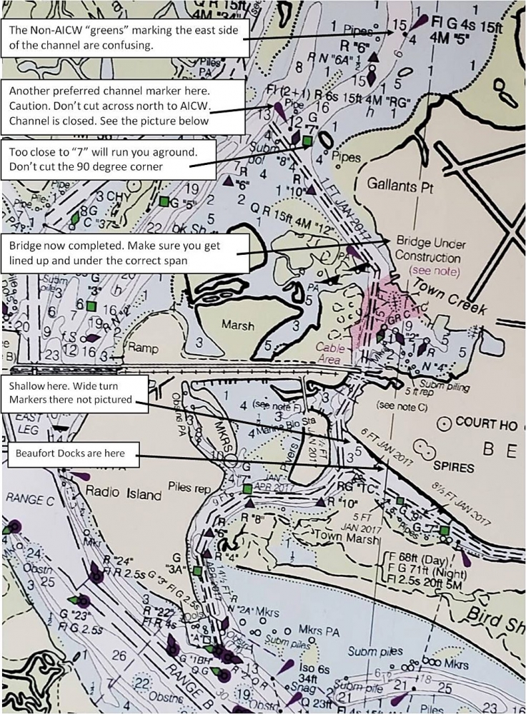
NOAA chart number 11545 for the Beaufort Inlet.Here’s a photo of the 90 degree turn, north of the newly constructed Beaufort Bridge. View is facing east:
East facing view of the new Beaufort Bridge.• The current in Beaufort rips through Taylor Creek. Ebbing current usually runs about 1 knot while flooding current runs about 1.5 knots. Add 15 knots of sea breeze and docking is now (officially) a varsity event. When cruising to Beaufort, I research all these numbers remembering high and low tides (times) are not the same as slack current (times):
- Max flood current Beaufort - When the incoming current is the strongest
- High tide Beaufort - When the water level is the highest
- High slack current Beaufort - No current during the high tide cycle – Preferred arrival time
- High tide at the Core Creek Bridge (clearance) - Time of least vertical clearance under the Bridge
- Morehead City Bridge - Time of least vertical clearance under the Bridge
- Beaufort fixed Bridge - Time of least vertical clearance under the Bridge
- Max ebb current Beaufort - When the outgoing current is the strongest
- Low slack current Beaufort - No current during the low tide cycle – Preferred arrival time
- Low tide Beaufort - When the water level is the lowest
- Low tide at the Core Creek Bridge (clearance) - Vertical clearance optimal
- Morehead City Bridge - Vertical clearance optimal
- Beaufort fixed Bridge – Vertical clearance optimal
Good captains/cruisers are never surprised by the tides and current. Do your homework. What time will you arrive? Time equals distance divided by speed. (Need a navigation class?) To reduce your docking challenges, adjust your departure time to arrive in Beaufort at slack current.
Two additional points; when the wind blows from the north, the Neuse River fills up. High water levels in the Neuse can cause the water to flow south, down Adams Creek, regardless of the tides. And point number two; the tides flip in Beaufort first (south) and then the “reversing” works its way north up Adams Creek. It is possible, traveling south, to pick up an initial favorable current only to find yourself fighting the current further downstream.
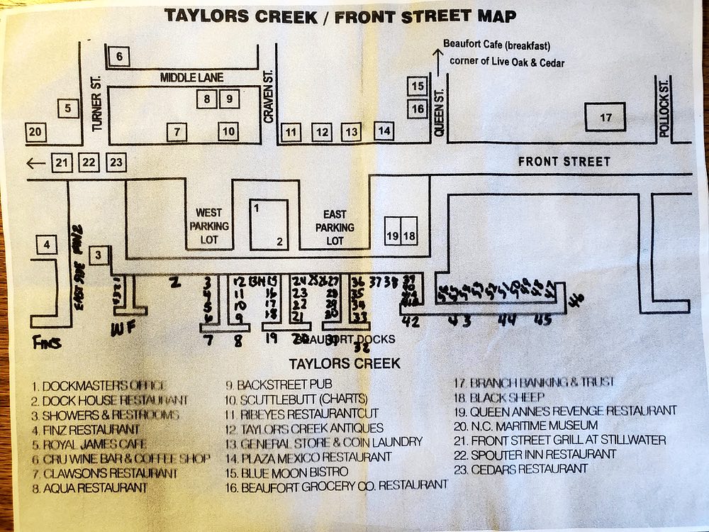
• There is no Beaufort Docks Marina diagram on the internet. As a result, finding your slip is difficult. And, if you are lucky enough to have their diagram, it often doesn’t matter because the dockmasters usually don’t assign a slip when you make a reservation. You’ll get your slip assignment when make your arrival radio call. This adds angst to an already challenging situation. The dockhands give you mediocre directions to your slip over the VHF. As a public service, here is my personal and well traveled diagram of the Beaufort Docks. You are most welcome. Now you can find your way if you have a slip number. If there is current, I highly recommend a “bow into the current” slip assignment. The Beaufort dockmaster is savvy enough to know this works best. They will do their best to make docking go well. Bow into the current is their standard practice. However, if otherwise, you may not get a “heads-up” until you’re “in close”.
Captains, before you approach these docks, you should have total situational awareness. Are you bow in to any current? What is the current going to do to your boat? Anticipate. Don’t be reactive. Be thinking ahead of the boat. Damaged gel coat is often the by-product of surprise. Also, your line handlers need a plan.
The Beaufort Docks Marina Diagram.In summary, I hope I have not deterred you from cruising to Beaufort. Go there. It is our favorite weekend destination. We really enjoy the town. But some homework will reduce the challenges and provide you with the experience you deserve.
Fair Winds,
Captain John Rahm
 Captain's Blog on TownDock.net is all about making your time on the water enjoyable. Captain John Rahm teaches sailing and boat handling at Third Wave Sailing. Captain's Blog on TownDock.net is all about making your time on the water enjoyable. Captain John Rahm teaches sailing and boat handling at Third Wave Sailing. |