It's Tuesday July 28, 2026
May 11, 2013
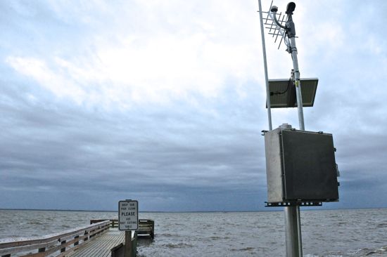
Lou-Mac Park has a new fixture – a river gauge. Thanks to the flooding that Oriental experienced in Hurricane Irene, the town joins about a dozen and a half eastern North Carolina river and coastal towns that have one.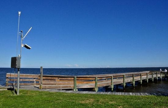 A sentry at the land end of the Lou Mac Park pier. It’s the newly installed “river gauge.”
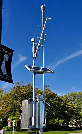
As a gauge — a “multi-sensor gauge” to be precise — it will send info about weather and river height conditions back to the state’s Emergency Management office in Raleigh. David Herlong, the NC Flood Warning Manager for the NC Division of Emergency Management’s Geospatial & Technology Management Office, says the gauge will measure rain fall, barometric pressure, wind direction and speed and wave and water levels.
As for that all-important bit of info — how much flooding this river town may experience, this system will measure that, too. A wire in a tube extending to the far end of the Lou Mac pier is part of a pressure transducer that Herlong says will be able to sense how high the water level is above it.
 Pier at Lou Mac Park. Two lines lead out to the end of the pier. one is the hose for washing off fish at the bait table, the other, is part of the Division of Emergency Management’s river gauge system.
Info gleaned from the two-poled structure cannot predict flooding conditions. It will “not do forecasts,” says David Herlong. But by sending the weather data, via a satellite transmitter on the pole to the Emergency Management office in Raleigh (and by extension, the local office in Bayboro — and to the National Weather Service) the hourly updates can be compared to what the weather forecasts and modeling for the storms had predicted.
David Herlong refers to it as “groundtruthing,” like looking outside a window to see if the forecast was right, except the peek at conditions comes via satellite. It’s a benefit, says Herlong, “any time you can ‘groundtruth’ the model.” For instance, Herlong says, if the prediction was for a 6 foot surge, and the gauge is showing 6 feet, that’s important information.
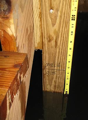
By integrating that storm surge data with the state’s “inundation maps” Emergency Management in Raleigh can get a better sense of what roads are below water and how many homes in Oriental and Pamlico County will see water in their first floor living areas.TownDock.net has provided surge measurements for the last decade using a somewhat less expensive device – a $12 Stanley measuring tape.David Herlong says that after Hurricane Floyd’s devastating floods in eastern North Carolina in the mid-1990’s, NC put together the “most detailed set of floodplain maps in the country… and the world.”
“We have building footprints and first floor elevations for all structures in the 500-year flood plain in Pamlico County,” Herlong says.
The state is also updating maps that show the elevation of all roads in the county. Coupled with the water level data that comes in from gauges such as the one at Lou-Mac Park, NC Emergency Management can warn the public that roads are about to be flooded or have flooded already.
Herlong says this gauge was installed in Oriental because the state “went to where people are” in order to help “reduce the loss of life and property.”
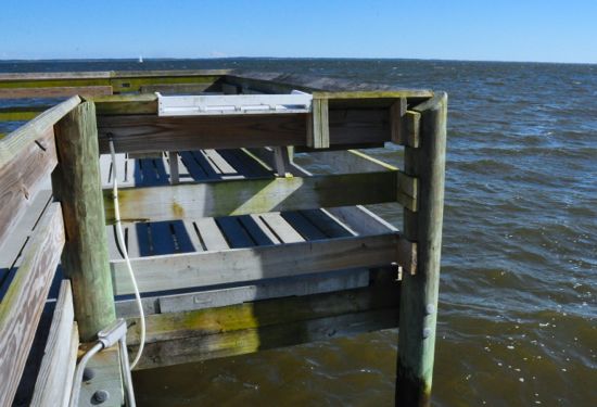
 Overcast skies but not enough to worry about flooding, at least on this day. When storm surges do come, the gauge system at the pier is supposed to send info about water height back to the Emergency Management office in Raleigh.
From a public safety standpoint, Herlong says warning about road conditions can be especially helpful. It’s when people try to flee a flood in their cars, he says, that they run in to trouble and sometimes die. “We can’t take the keys out of their hand,” Herlong says, but with the enhanced data, the state Emergency Management office can better issue warnings about which roads are “better to detour.”
With these updates of surge conditions measured hourly at Lou Mac Park, the state’s Emergency Management office can know earlier than before the extent of flooded homes. That could mean aid coming sooner to river and coastal towns such as Oriental.The gauge and satellite transmitter are powered by a solar panel up top. Meanwhile, in order to be able to operate through storms, the lowest point of the operation was installed, a state official says, at least a foot higher than the “flood of record” high water mark at Lou Mac Park.With similar gauges installed at Ocracoke and Cedar Island, Oriental provides the third point of a Pamlico Sound triangle. Herlong says the data collected from those three places during storms may help meteorologists “learn something” about the track of the blows and their surge.
The gauge in Oriental cost $20,000, says Herlong, and is one of 9 new gauges installed in Eastern NC with FEMA grant money. Belhaven got one, too, and this round of installations brings to a dozen and a half the number of these gauges on the coast and Eastern rivers. Another two dozen have been operating for years in the more mountainous – and flash flood-prone – regions of western NC.
In scouting out locations for the gauges, Herlong visited Oriental over the winter, meeting here with representatives from Newport’s National Weather Service. One of those meteorologists noted that til now, they’d used the dragon in Oriental’s Duck Pond – as seen on TownDock.net’s Harborcam as an effective wind indicator, its nose pointing in to the wind (less visually interesting, but a somewhat more accurate indicator is the Oriental Weather Station).
The dragon will continue to do its dance on the Duck Pond, while the new gauge at Lou Mac should provide state officials and NOAA meteorologists with new surge details.
Level readings from the Surge Gauge can be seen online on TownDock.net.