It's Tuesday October 21, 2025![]() Dock Quote: “It is not...
Dock Quote: “It is not...
News From The Village Updated Almost Daily
| ||||||||||||||
Post-Tropical Cyclone Andrea Forecaster's Discussion # |
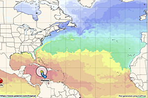
| A graphic showing several computer modeled projected tracks is at the bottom of this page. |
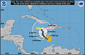
Post-Tropical Cyclone Karen Discussion Number 4 NWS National Hurricane Center Miami FL AL112025 900 PM GMT Fri Oct 10 2025 Convection associated with Karen has dissipated this evening, leaving the system a swirl of low- to mid-level clouds. The cyclone will be moving over even colder waters of the North Atlantic during the next 12 to 24 hours, and organized convection is not expected to return. Therefore, Karen has lost its designation as a subtropical cyclone, and this will be the last NHC advisory. The initial intensity remains 40 kt, based on earlier ASCAT data. The low should gradually weaken during the next 12 to 24 hours, and it is expected to open up into a trough and be absorbed by an approaching frontal system in 24 to 36 hours. The low is moving north-northeastward or 025 degrees at 14 kt. The system should continue to accelerate north-northeastward ahead of an approaching deep-layer trough through Saturday. The updated NHC track forecast is once again similar to the previous forecast and near the center of the guidance envelope. This is the last NHC advisory on Karen. Additional information on this system can be found in High Seas Forecasts issued by Meteo France under WMO header FQNT50 LFPW and available on the web at https://tgftp.nws.noaa.gov/data/raw/fq/fqnt50.lfpw..txt FORECAST POSITIONS AND MAX WINDS INIT 10/2100Z 47.5N 30.2W 40 KT 45 MPH...POST-TROPICAL 12H 11/0600Z 49.4N 29.0W 35 KT 40 MPH...POST-TROPICAL 24H 11/1800Z 53.5N 27.1W 30 KT 35 MPH...POST-TROPICAL 36H 12/0600Z...DISSIPATED $$ Forecaster Brown |
The Forecaster's Discussion above often refers to several computer models. The graphic below includes multiple projected paths, showing what the different computer models indicate. The black line is the NHC (National Hurricane Center) path. This graphic is not an official NHC product. For the official NHC projected path of Post-Tropical Cyclone Andrea click here.

click image for a larger view
For more information about tropical storm computer models click here.