
It's Sunday December 7, 2025![]() Dock Quote: “I suffer from...
Dock Quote: “I suffer from...
SMALL CRAFT ADVISORY IN EFFECT FROM MONDAY MORNING THROUGH MONDAY EVENING

Remnants of Jerry Forecaster's Discussion & Computer Models
| ||||||||||||||
Remnants Of Jerry Forecaster's Discussion # |
| A graphic showing several computer modeled projected tracks is at the bottom of this page. |
Remnants Of Jerry Discussion Number 18 NWS National Hurricane Center Miami FL AL102025 500 PM AST Sat Oct 11 2025 A combination of scatterometer data, GOES-East derived motion winds, and a recent GPM microwave pass seems to confirm that Jerry does not have a well-defined center and has degenerated into a trough with deep convection located at the southeastern end of the axis. As a result, this will be the last NHC advisory on this system. Maximum winds are estimated to be 40 kt based on ASCAT data from this morning. The rough motion estimate is northward, or 360/14 kt. The remnant trough is expected to move northward and then northeastward, with the European, Canadian, and UKMET models showing it merging with a frontal boundary to its north in 24-36 hours. Gale-force winds are likely to continue to the east and north of the trough until it merges with the front. The GFS continues to keep the remnants as a distinct feature, but given that its initial position of the remnants is too far to the southeast, it is still considered an outlier solution. Additional information on this system can be found in High Seas Forecasts issued by the National Weather Service, under AWIPS header NFDHSFAT1, WMO header FZNT01 KWBC, and online at ocean.weather.gov/shtml/NFDHSFAT1.php FORECAST POSITIONS AND MAX WINDS INIT 11/2100Z 27.6N 63.6W 40 KT 45 MPH 12H 12/0600Z...DISSIPATED $$ Forecaster Berg |
The Forecaster's Discussion above often refers to several computer models. The graphic below includes multiple projected paths, showing what the different computer models indicate. The black line is the NHC (National Hurricane Center) path. This graphic is not an official NHC product. For the official NHC projected path of Remnants Of Jerry click here.
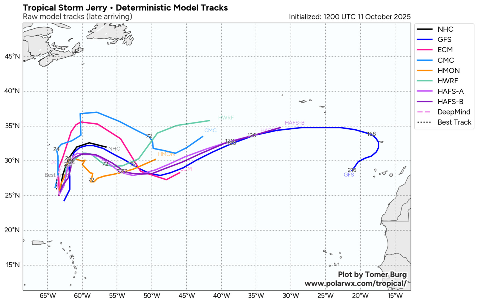
click image for a larger view
For more information about tropical storm computer models click here.


Dock Quote:
I suffer from the...
Recent Stories: