It's Saturday November 22, 2025![]() Dock Quote: “You have to...
Dock Quote: “You have to...

Remnants of Lorenzo Forecaster's Discussion & Computer Models
| ||||||||||||||
Remnants Of Lorenzo Forecaster's Discussion # |
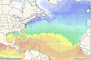
| A graphic showing several computer modeled projected tracks is at the bottom of this page. |
Remnants Of Lorenzo Discussion Number 11 NWS National Hurricane Center Miami FL AL122025 500 PM AST Wed Oct 15 2025 Visible satellite imagery shows that Lorenzo no longer has a well-defined circulation and has dissipated. Recent microwave imagery also suggested that the system had opened to its west. Satellite intensity estimates have decreased as well, indicating that Lorenzo has lost its organized convection. The initial intensity is lowered to 30 kt based on a blend of these estimates. The remnants of Lorenzo have turned northeastward and are moving an estimated 16 kt. This general motion with an accelerated forward speed is expected for the next day or so. Additional information on this system can be found in High Seas Forecasts issued by the National Weather Service, under AWIPS header NFDHSFAT1, WMO header FZNT01 KWBC, and online at ocean.weather.gov/shtml/NFDHSFAT1.php FORECAST POSITIONS AND MAX WINDS INIT 15/2100Z 23.1N 42.5W 30 KT 35 MPH 12H 16/0600Z...DISSIPATED $$ Forecaster Bucci |
The Forecaster's Discussion above often refers to several computer models. The graphic below includes multiple projected paths, showing what the different computer models indicate. The black line is the NHC (National Hurricane Center) path. This graphic is not an official NHC product. For the official NHC projected path of Remnants Of Lorenzo click here.

click image for a larger view
For more information about tropical storm computer models click here.