
It's Saturday June 20, 2026![]() Dock Quote: “Take me to...
Dock Quote: “Take me to...
News From The Village Updated Almost Daily


Fireworks Fundraiser
Upcoming Events
- This Week @ New Village Brewery, June 18-21
- Wine Tastings @ Nautical Wheelers - Jun 19 & 20
- Oriental Farmer's Market - Saturday
- Silospalooza 2026 - June 20
- Mariposa Wine Bar & Bakery: Jun 20-22
- Walk / Pedal for Parkinson's - June 20
- Sunday Morning Services Riverside
- The Jeff Little Trio at The Old Theater - June 21
Letters: Pecan Tree Stalemate:
Two paths forward. Letters To The Editor
The Pig Celebrates 10 Years:

A decade serving Oriental. The Story
NOAA's Prediction: A Below Average Hurricane Season:

But will a storm visit here?. The Story
Sara's Last Sail:

A boating equivalent to organ donation. Captain's Blog
Letters: Reevaluate Property Tax Revaluations:

Revaluation data inconsistent, inaccurate. Letters To The Editor
From Argentina to Whortonsville:

Zonda Group finds a home near Oriental. The Shipping News
Letters: Thanks from the Oriental Rotary Club:

Grateful for the community support, proud of the difference we make. Letters To The Editor
Cycle NC 2026:

Over a thousand cyclists visit Oriental. The Story
April Town Board Meeting 2026:

Pickleball court placement settled, volunteers needed. The Story
Zac Schnell, AI and Community Engagement:

A New Path for Pamlico Community College. The Story
The 2026 Oriental In-Water Boat Show:

Power boats, sailboats and a beer garden. The Story
Eston “Sherrill” Styron, 1942 - 2026:

Husband, Father, Friend and Mayor. The Story
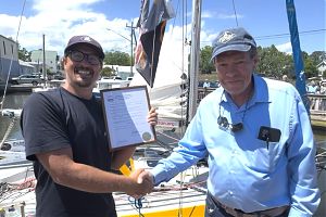
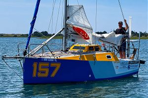
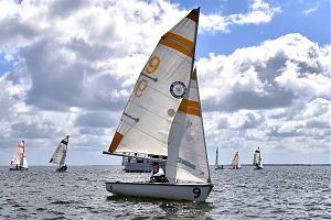
Capsizing on the Creeks: SailPack 2026:
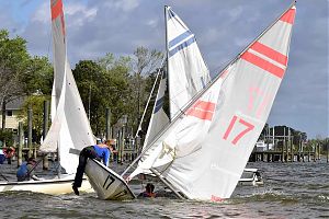
19 teams converge on Oriental. The Story
Letters: SailPack Regatta - Thanks To A Sailing Town:
Friendship, generosity, and hospitality. Letters To The Editor
Letters: Thanks From the Ragan Family:

Grateful for the community support. Letters To The Editor
2026 PAWS Pet Parade:

168 canine legs strut their stuff. The Story
Letters: Thank You Oriental:

Gratitude from the family of Russ Stevenson. Letters To The Editor
Weekend Preview: Sailpack 2026:

The 10th Annual Sailpack Oriental Intercollegiate Regatta returns to Oriental. Guest Columnist
The Dragon Burn That Didn't:
Live Music, Chinese Dragons, and a Fire Dancer. The Story
James "Jimmy" Edward Ragan, III, 1941 - 2026:

Judge, storyteller, civic leader. The Story
Letters: Leave Lupton Park Alone:

Neighbor says expansion will benefit few. Letters To The Editor
March Town Board Meeting 2026:

Special Use Permits, unauthorized expenses, and dog dirt. The Story
Loblolly Pines & Pollen:

It's trees in love. The Story
Luna the Catamaran Cat:
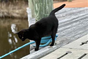
A cool cat at Marine Craft. Pet Of The Month
Letters: Working To Restore Hodges Street:

Commissioner Says Thanks. Letters To The Editor
Russell "Russ" Bryan Stevenson, 1932 - 2026:

"Notorious in the best small town way". The Story
Town Board Acts Fast in Fight for Funds:

Congressman Don Davis visits Oriental. The Story
February Town Board Meeting 2026:
Property fraud alert, new Chief of Police sworn in. The Story
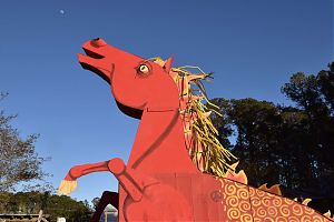
2026 Chinese New Year:

Year of the Fire Horse. The Story
Mads and SV Spiffy:
YouTube DIYer tackles new project in Oriental. The Shipping News
Michael Edward North, 1950-2025:

Husband, loving family man, outdoorsman, US Marine. The Story
Letters: Thank you for your Kindness:

A request answered. Letters To The Editor
January Town Board Meeting & Workshop:
A new Police Chief is named. The Story
Letters: In Praise of Neighbors:

Community arrives with help. Letters To The Editor
Oriental Snow Days:
Pictures from the February snow storm. The Story
Katy Burke & Taz Waller:

Two people, three boats, nine homes, four decades. The Story
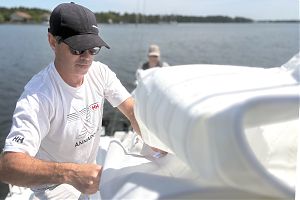
Winter Canvas Tips:

Boat canvas & winter weather. Canvas Corner
Instead of Football Regatta 2026:

32 years of a New Year's tradition. The Story
Friends Of The Dragon 2026:

It takes a village to house a dragon. The Story
Cathy Sue Brugett, 1954-2025:

TV host, sailor, wife, daughter, volunteer. The Story
December 2025 Town Board Meeting:

New board sets a positive tone. The Story
The Spirit of Christmas 2025:

Five Grinches, grits, and a polar bear. The Story
2025 Spirit of Christmas Schedule:

What's happening, where and when. The Story
Mary Watson Duffie, 1938-2025:

Teacher, musician, wife & mother. The Story
November 2025 Town Board Meeting:

Road repair fund set, green bin dumper busted. The Story
Turkey Pedal 2025:

Pedaling to earn their dinner. The Story
Giving Locally 2025:

Area Non-Profits That Could Use Your Donations. The Story
David George Wright, 1949-2025:

Husband, father, sailor, proud grandfather. The Story
2025 Oriental Cup Regatta Results:

Oriental Express 1st Spinnaker, Il Gatto 1st JAM. The Story
Dredging Starts Soon:

A new route for Whittaker Creek Channel. Guest Columnist
Election Results 2025:

Jordan, Moffat, Cooper, Ostendorff and McGuire elected. The Story
Chili Cookoff 2025:

Twelve chilis for 300 tasters. The Story
Oriental Candidates' Forum 2025:

Nine contenders speak to a packed house. The Story
Letters: We Will Still Be Neighbors:

Looking forward. Letters To The Editor
October 2025 Town Board Meeting:

Robert's Rules Of Order restored. The Story
A History of Sailmaking in Oriental:

Making Sails in North Carolina's Sailing Capital. The Story
Meet the 2025 Oriental Town Board Candidates:

Eleven candidates for five seats. The Story
Sharon Rose Howard, 1938 - 2025:

Mother, teacher, friend. The Story
George Hughes Beckwith, Jr. 1970-2025:

Outdoorsman, Storyteller, Husband. The Story
Ol' Front Porch Music Festival 2025:

Two perfect days draw a crowd. The Story
Virginia Ann Thorn, 1933 - 2025:

Loving wife and mother. The Story
Letters: Thank You from the Board of the Ol’ Front Porch Music Festival, 2025:

William "Bill/Will" Frederick Schmitt, 1948 - 2025:

Sailor, man of faith. The Story
September Town Board Meeting 2025:
Sandy Winfrey fills vacancy. The Story
Letters: Multiple Views On The Upcoming Town Elections:
The role of a commissioner in a healthy town government. Letters To The Editor
Michelle McKee Fodrey, 1953-2025:

Mother, wife, respected realtor. The Story
Scenes from a Wednesday Night Sail:

A calm weekly 'race' on the waters off Oriental. The Story
A Commissioner Resigns... What's Next?:
An attempt to change the rules on how it's done. The Story
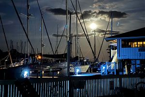
Nighttime moves over the Neuse River (and a sailboat at anchor). As seen from South Avenue, approximately 8:45p, Friday evening. (Allison DeWeese photo)
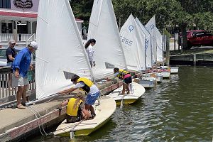
3:58p This weekend in Oriental, choose your live music experience: Friday at the Brewery & Red Rooster, Saturday’s all-day music event Silospalooza, or Sunday’s piano-playing bluegrass band The Jeff Little Trio. 
Or you can do all three days.
Tonight at the Brewery, Jasmine Tasty Thai serves now until 8p, with Songs from the Road Band live in the beer garden, 5-7:30p. A little ways down Broad Street, Ken Belangia performs at the Red Rooster at 7p.
Saturday morning, walk or peddle for Parkinson’s starting at Lou Mac park at 9a. Get your fresh eggs and more at the Oriental Farmer’s Market, 8-1130a. Enjoy wine tastings at Nautical Wheelers at 2 & 3p.
Silospalooza, the free outdoor music event, celebrates 13 years. Bands play from noon to 9:30p. Pizza eating contest at 4:30p. Foods, drinks, or barbecue available for purchase. It’s all behind the Silos on Broad Street.
Sunday morning, OUMC holds riverside services at Lou Mac Park at 8:30a. The Jeff Little Trio take the stage at The Old Theater Sunday at 3p.
Have a listen to The Jeff Little Trio:Mariposa serves fresh baked goods Saturday, Sunday, & Monday 7-11a, and charcuterie & wine flights in the evenings, 3-9p. For Father’s Day, Mariposa serves a special charcuterie board to celebrate Father’s Day this weekend, including beef with caramelized onions, and mashed potato balls.
Broad Strokes gallery is open all weekend, featuring June artists of the month Charlie and Susan Frye.
It’s all in What’s Happening.
11:10a Today marks 39 years since Mariner Realty began selling homes in Oriental. Celebrate with them and get a free lunch, now until 2p at their offices on Broad Street, next to New Village Brewery.
El Taco Loco serves tonight at the Brewery, 4-8p.
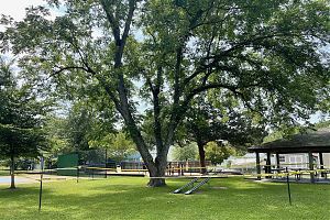
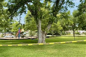
The pecan tree in Lupton Park is coming down. The Oriental Tree Board invites you to take some of the wood, for use or posterity.
If anyone is interested in wood, whether to have it cut into lengths for lumber, firewood, or just want a section for posterity, please be there in person to haul away your pieces yourself. Crews usually begin in the early morning. It would be a worthy final act recognizing that while the tree shows signs of decay and is no longer suitable for a public park, the wood has purpose and will continue to be useful whether it is used to build furniture or keep your home warm.
11:24a This morning’s rain shower dropped a little over half an inch of rain in Oriental. It’s been a total of 1.66 inches of rain for June, and is likely to increase Friday: there’s an 80% chance of thunderstorms moving through the area.
Today, highs are in the mid-80s with humidity around 80%. A more bearable situation than the sweltering heat of last week.
El Taco Loco is serving lunch at Triton Yachts today, and the Wednesday Night Sail takes a turn around the marks this evening at 5p.
It’s also Open Mic Night at the Silos at 7p. You can attend in person.
Six years ago, that wasn’t the case. The world shut down, but Open Mic Night went on – streamed live online. TownDock.net was there.
4:50p Grosvenor Barber passed away yesterday. He was 96. Grosvenor was a father, husband, sailor… and the long time Dockmaster at Pecan Grove Marina. A character, an original.
Grosvenor in the 2008 Croaker Festival parade:

Spirit Of Christmas parade, 2013:

7:56a After weekend thunderstorms and a heat index near 100, the first part of the week offers a slight reprieve: partly to mostly sunny with highs in the mid to upper 80s. Only a 20 – 30% chance of rain.
90 degree weather returns briefly at the end of the week.
On the Neuse, winds are from the west at 10-15 knots, becoming 5-10 knots later this morning and afternoon.
• Oriental NC Forecast
• Neuse River Marine Forecast
• Oriental Water Level Gauge
• Oriental Weather Station
2:07p Power is back at the Piglet – the breaker is fixed – all is good for a 3p reopening.
From Billy Flockhart:A large breaker broke – stopping one leg of power to get to the store. All the power wasn’t out – any food that was effected was thrown out.
The breaker failure also prevented the generator from being able to provide backup power.
8:14a Power went out at The Piggly Wiggly in Oriental at 5p last night. It is still out this morning, the store is closed.
Apparently a large breaker failed, stopping one leg of power. This is preventing the back-up generator from working too.
Owner Billy Flockhart is at the store – he says a replacement part is on the way (coming from Burlington, NC). An electrician will install that when it arrives – Billy hopes to reopen at 3p today.
4:17p Tonight, after a delay due to a burn ban, the Pamlico County Arts Dragon burns. 
Doors open at 6:30p at The Silos. The burn starts at sundown.
La Cocina del Coqui serves Cuban fare at the Brewery, 4-8p. Eugene Wheeler (one half of YardSail) performs 6-8p in the beer garden.
Saturday is the Oriental Farmer’s Market, 8-11a. Los Gordos food truck serves 5-8p at the Brewery and NottaBand performs 6-8:30p.
Sunday, visit Lou Mac Park for Oriental United Methodist’s riverside service, 8:30a. Paddle for Parkinson’s Research at 9a, leaving from the Wildlife Ramp on Midyette St. Black Panther plays at The Old Theater at 3p.
Broad Strokes gallery is open all weekend, featuring June artists of the month Charlie and Susan Frye.
Mariposa serves fresh baked goods Saturday, Sunday, & Monday 7-11a, and charcuterie & wine flights in the evenings, 3-9p. ‘Second Sunday Soup’ is on offer from 11a-2p, serving chilled soup, gazpacho, with homemade bread and focaccia.
It’s all in What’s Happening.
Oriental’s waters tested clear for bacteria this weekend, according to the Sound Rivers’ Swim Guide. Not all waters passed the test. Read the full Swim Guide results here.
10:45a If you are approached and asked about registering for the upcoming November election, be cautious.
An incident at the Piggly Wiggly and the Grantsboro Walmart has Oriental Police Chief Bill Wichrowski issuing this notice:
 They are approaching people trying to get their social security numbers and personal information.
 If seen, stop and identify the occupants and get any information from them regarding their employer. We need to verify they are legitimate. Thanks
Contact the Oriental Police Department at (252) 249-0369 or the Pamlico County Sheriff’s Office at (252) 745-3101.
9:57a Fresh wild caught Alaska salmon, available in Oriental? Doug Sligh writes in:
 She warned us it would be more expensive than farmed Atlantic salmon, and she was right. But there is nothing quite as good as grilled or sauteed Chinook salmon.
 The Chinook season in Alaska is now open and Jeff is looking to place an order for us – the price will be $28 per pound.
If you are interested in ordering fresh Chinook salmon, send an email message to Doug Sligh at mapdls@gmail.com with Salmon in the subject line and your name, phone number, and the number of pounds in the body of the message. Jeff expects delivery in mid-July.
9:40a The Dragon Burn tonight… is for the year of the horse. Artist Laura Turgeon was inspired:

More about tonight’s Dragon Burn here.
11:00a The County has called another Special Budget Meeting for Friday afternoon, June 12 at 3:30p in the courthouse annex.
Taco Loco Food truck is serving at Triton Boat Yard today for lunch.
This evening, join the Wednesday Night Sail on the water at Oriental Marker #1SC at 5p. It’s Open mic Night upstairs at the Silos, 7p.
9:03a At last night’s monthly Town Board meeting, Commissioners opened, and then continued the budget hearing without a vote until the end of the month, pending ongoing budget legislation in the General Assembly. 
Commissioners heard from residents regarding the pecan tree at Lupton Park, and spent time discussing the reports, the expert opinions, and the legalities involved. They voted that the tree be removed.
A full meeting report is coming.
12:55p Tonight is the monthly meeting of the Oriental Town Board, 6p at Town Hall. On the agenda, a public hearing on the town budget, a tree, traffic, parks and the usual discussions of running a small town. The public is invited.
That tree the board will be discussing is a Pecan Tree at Lupton Park. Letters have been written in from the Oriental Tree Board, and citizens. Like life, there are differing views on a tree. Read more here.
Wednesday Neuse Neighbors holds their monthly coffee hour, a get-together for folks to learn more about the organization. Neuse Neighbors defines itself this way:
The coffee hour is 9a, Oriental Town Hall.
11:53a A pecan tree in Lupton Park has a few residents stirred up. Decay has rendered it a liability.
Dr. Bob Miller, former chair of Oriental’s Tree Board, Emeritus Professor of Urban Forestry at the University of Wisconsin, and the man who helped write the actual textbook on trees in urban spaces, Urban Forestry: Planning and Managing Urban Greenspaces, says the tree needs to come down.
Some residents disagree.
They want to maintain the tree as long as possible.
A letter from the Tree Board explains where things currently stand. Read it here.
1:52p Sunny weekend ahead, highs near 90. There’s live music, an artists’ reception, and the Brewery is open for summer Sundays.
Tanja’s German Street Food is at the Brewery tonight, serving Döner sandwiches, 5-8p. Hoff ‘n’ Finch perform live in the beer garden, 6-8:30p. Down the road, Mac McWilliams performs on the Bantam Stage at the Red Rooster, 7p.
Pick up fresh greens Saturday morning at the Oriental Farmer’s Market on Saturday, 8-11a. Meet artists Featured Artists for June, Charlie & Susan Frye, at Broad Strokes Gallery’s Artists’ Reception, 2-5p. At the Brewery, it’s Taqueria San Luis, 4-8p and Packhouse plays live, 5:30-8p.
The Brewery is now open Sundays (now til Labor Day weekend). All About Churros serves on site, 2-6p.
Mariposa serves fresh baked goods Saturday, Sunday, & Monday 7-11a, and charcuterie & wine flights in the evenings, 3-9p.
It’s all in What’s Happening.
West Marine has filed for Chapter 11 bankruptcy. 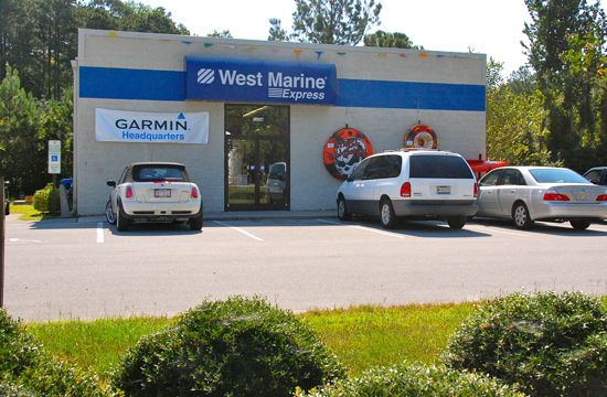 While the nationwide chain is expected to continue with about 200 stores, they are closing 59 West Marine locations as part of restructuring the business.
Among those is the West Marine in Oriental.
Store manager Ann Fetter tells TownDock that the store will be open, normal hours, through the end of August. After that, the store will close.
The West Marine in Oriental first opened in 2004.
Oriental is fortunate to have a locally owned marine store, The Provision Company, which has been a part of town since the mid 1980s: theprovisioncompany.com.
Next door to the West Marine, is locally owned Seacoast Marine Electronics, providing marine electronics including a showroom of Raymarine and Garmin gear.
Village Hardware, also locally owned, carries a significant stock of marine supplies.
 The Sound Rivers Swim Guide tests local waters for bacteria and lets you know whether or not those waters are safe for swimming. This week, two sites failed. Once of them is Pierce Creek in Oriental.
From the Swim Guide: “A ‘Swim Guide fail’ means elevated levels of fecal bacteria, which can come with increased risk of gastrointestinal illness and skin infections for pets and humans alike.”
Read the full press release here.
4:07p If you see Dick Koepp today, it’s Happy Birthday #80:

Many people only know him and Josie as they ride through town daily at 9a and 4p
There is another Special Meeting on the horizon – this one from County Commissioners.
Pamlico County Commissioners have called a Special Meeting to discuss the County Budget, scheduled for Monday, June 8 at 5:30p at the courthouse annex in Bayboro.
8:53a Sunny and high near 80 today, north winds 10-15 mph with gusts up to 25.
Today you can grab a taco, catch a special town meeting, sing your heart out, or take an evening sail on the Neuse.
Here’s the timeline of Wednesday’s events:
11a: Taco Loco Food truck sets up to serve at Triton Yachts
1p: Special Meeting at Town Hall on Property Tax Assessments
5p: Wednesday Night Sail starts at Oriental Marker #1SC
7p: Open Mic Night at The Silos
6:27a Mayor Sally Belangia has called a Special Meeting at Oriental’s Town Hall for Wednesday, June 3 at 1p.
Town has received new information from Pamlico County on the recent property tax assessments. Some residents found their proposed annual property tax had increased two or three times what it had been. The deadline to submit a timely appeal was May 11.
Commissioners and the Mayor will discuss the new information regarding property assessments, including appeals that have been granted and the resulting impact on the proposed budget.
This meeting is open to the public.
9:18a The sun comes up every morning. And every June 1st marks the first official day of Hurricane Season. Welcome. Hurricane Season is with us through November 30.
The Tropical Storm Outlook is updated four times a day (sometimes 8x a day during storms) in TownDock’s Hurricane Center.
Usually there isn’t anything going on on June 1. Usually is more difficult to define in recent years, but indeed the message this morning is good:
“Tropical cyclone formation is not expected during the next 7 days.”
The storm names for 2026:

NOAA (and others) are predicting a milder hurricane season for 2026. But it just takes one.
Should a storm form and head this way, you can count on TownDock.net to track & report on that storm. We have stayed in town (we’re not very smart) and reported in real time on every hurricane, since 2002.
7:26a 70% chance of rain today. High near 80. S winds 5-10mph.
On the Neuse, winds are at 5-10 knots.
There is a Small Craft Advisory in effect for Tuesday. Winds will be out of the east around 10 knots tonight, becoming NE 15 To 20 knots after midnight with gusts up to 30 knots.
Broad Strokes Gallery holds their bimonthly Open Studio, 9a-noon. You must register if you’d like to participate, but it’s free to stop by and watch local artists at work.
Get on the water on Bow to Stern’s fleet of Typhoons any Monday afternoon at 3 & 5p. For more info & to register, click here.
Pamlico County’s Board of Commissioners meeting is tonight at 7p at the County Courthouse. Agenda and documents are here.
8:50a Water levels snuck up to almost 2 feet above “normal” yesterday. There are coming back down a bit this morning, and will drop more this evening (south winds forecast).

• Oriental NC Forecast
• Neuse River Marine Forecast
• Oriental Water Level Gauge
• Oriental Weather Station
Ten years ago Oriental had become a “food desert” – no local grocery store. Then Oriental’s Piggly Wiggly opened – this week Oriental celebrated a decade of the Piglet.
A partly sunny day ahead, small chance of thunderstorms this afternoon.
• Oriental NC Forecast
• Neuse River Marine Forecast
3:55p Wine tastings, live music, and painting with Charlie Frye. 
Friday night Ken Belangia, Kim Brookshire and Shawn Aldridge play the Brewery Beer Garden 6-8p, Capone’s: A Taste of Philly serves 4-8p.
George Bailey plays down the road at The Red Rooster Pavilion starting at 7p.
Get fresh eggs Saturday morning at the Oriental Farmer’s Market, 8-11a. Sample Malbec wines from Argentina at Nautical Wheelers at 2 & 3p.
A Taste of Philly food truck serves from 5-8p at the Brewery while TerraTones plays, 6-8p.
Join Charlie Frye at Nautical Wheelers for a Paint & Wine afternoon, 3-5p. Limited to 10 participants – tickets available online or at Nautical Wheelers.
The 5th Sunday sing happens at 6p – this time at St. Peter the Fisherman Church. All are welcome.
Mariposa serves fresh baked goods Saturday, Sunday, & Monday 7-11a, and charcuterie & wine flights in the evenings, 3-9p. They will be closed Saturday evening for a private event.
If you’re looking for this week’s Sound Rivers Swim Guide for local waters, you can find it here.
Legendary 1983 Wauquiez 43 Amphitrite – $135,000
Yamaha 2007 Electric Golf Cart
Piano free to good home
Have Your Rig Tuned 252.617.3134
Sailing Lessons on Your Boat 252.617.3134
Rice Hull Mulch, Approx: 500lbs - Free Delivery
Protected Deep-Water Dockage & Home - Pierce Creek
SOLD - 2014 Subaru Crosstrek AWD
Seeking Full Tme Cook & Kitchen Staff
Free Couch
402 Hodges Street- See it Today
Local Lawncare & Pool Services
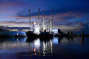
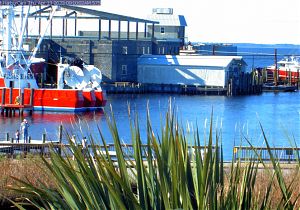
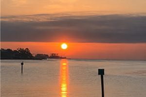
Recent cover photos: